Lorne Victoria Australia
Lorne Historical Society has documented the story of the coastal settlement. The first story of Lorne is of the Gadubanud (King Parrot) people who occupied the rainforest plateau and rugged coastal area of the Wada Wurrung to the northeast, Gulidjan to the north and Girai Wurrung to the west. Today the Gunditjmara people are the traditional custodians of Gadubanud lands, although there are indigenous people in the area today who trace their ancestry to the Gadubanud.
It is known that the Gadubanud people traded spear wood for green stone mined by the Wurundjeri when tribes met at traditional ceremonies around the Gariwerd district. The Gadubanud made bark canoes for use in the rivers, lakes, estuaries and along the coast.
They had a varied diet. The many middens along the coast show fragments of turban shells, abalone, periwinkle, elephant fish, chiton, beaked mussel and limpets. It is known that seals, Cape Barren geese, eels and ducks were also eaten, along with New Zealand spinach, tubers and berries.
During the 1830s Gadubanud successfully avoided interactions with European settlers. Early squatters thought the area was uninhabited. At least five clans are recorded, including Bangura gundidj, Guringid gundidj, Ngalla gundidj, Ngarowurd gundidj and the Yan Yan Gurt clan. The Gadubanud were considered mainmait (wild) by neighbouring language groups the Wada Wurrung and Girai Wurring.
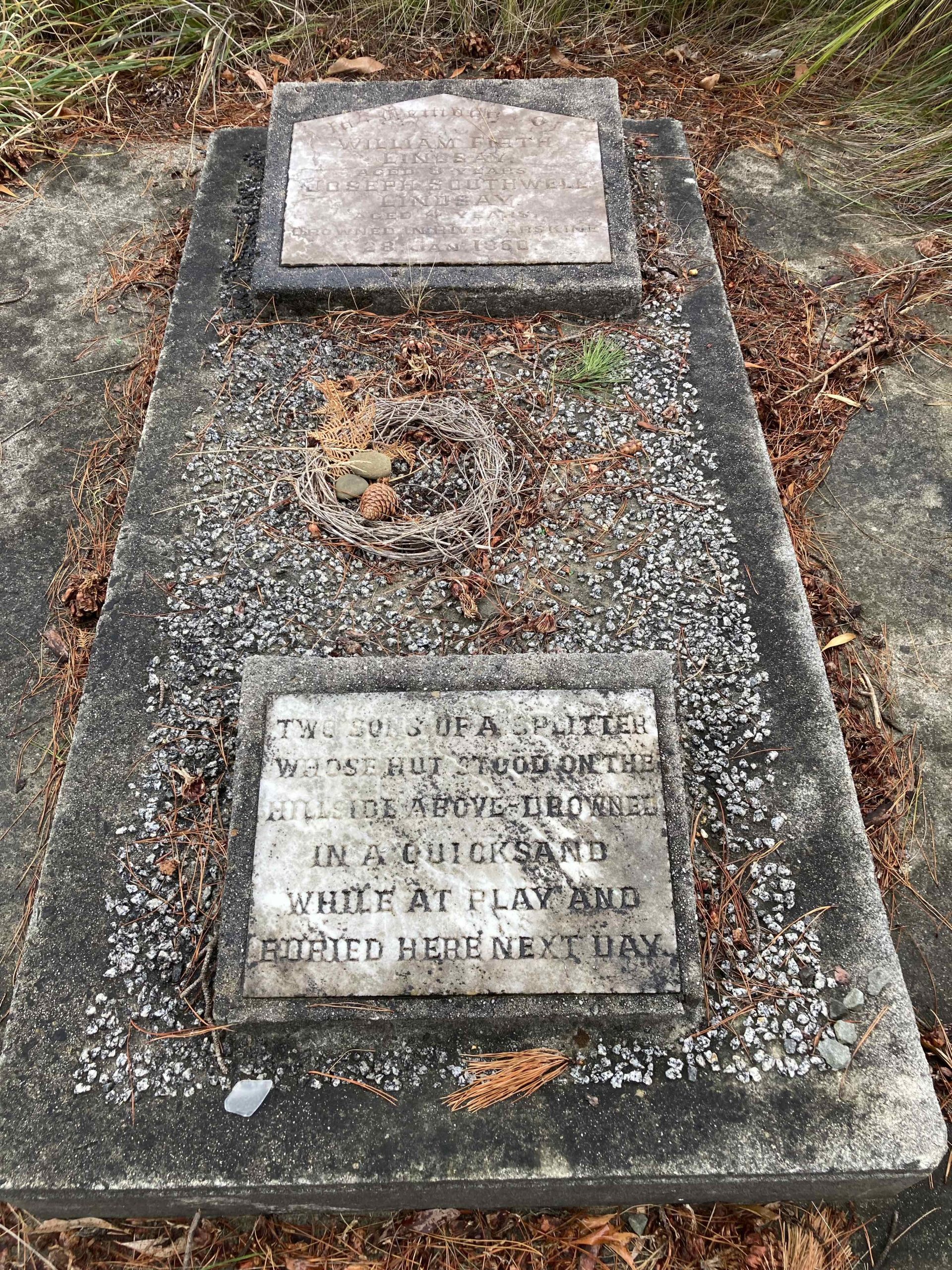
The area became a source of timber for European settlement when William Lindsay, searching for coal, discovered many valuable stands of timber along the coast. In 1841, the bay was used by Captain Louttit when his schooner, Will Watch, was forced into the bay by a heavy north-westerly gale. After four days he travelled to Melbourne and reported the bay as an ideal place to shelter.
In 1846, surveyor George Smythe had the name Louttit Bay registered at Superintendent Latrobe’s office in Melbourne.
In 1849 Lindsay was granted a splitter’s licence to cut timber. He built a dwelling on the north side of what is now the Swing Bridge at the mouth of the Erskine River. In 1850, tragically his two sons, William and Joseph, were smothered when the tunnel they were building collapsed.
In 1853 the Louttit Bay Cattle Station was commenced by John Herd. He was succeeded by William Aspen in 1855 and later a grazier named Short took up the land in 1862. Two years later in 1864 the Mountjoys brothers, Thomas, Caleb and Lawrence, took over the station. Later they built a two-roomed dwelling was the first rate-producing property at Lorne for the Winchelsea Shire.
Many of the cattlemen spoke of the natural beauty of Lorne, the word spread and the demand for accommodation increased, prompting the Mountjoys to build the Temperance Hotel, which eventually became Erskine House.
B57 Plane Crash
Two U.S. Air Force crew, Lieutenant Glen Harold Sprague 27 (pilot) and Lieutenant Bobby Edward Gelbrecht 26 (navigator), both of the 57th Weather Squadron USAF were killed in a tragic crash on Tuesday 16 October 1962, during the time of the Cuban missile crisis. It was one of four B57 aircraft in the American 57th...Read more
Batsons’ Pool
Many Lorne locals and visitors have enjoyed a dip in this magical pool on the beach of North Lorne, often deep enough for people to dive off the rocks and enjoy swimming. It is roughly opposite the intersection of Stirling Street and the Ocean Road in North Lorne or Little Colac. From the 60s onwards...Read more
COVID
Infectious diseases have ripped through the fabric of humanity for thousands of years. More than 7 million people have died of COVID to July 2026. A flu pandemic killed 17 million people in 1918. The Black Death killed half of Europe’s population in the 14th century. Before it was eradicated, smallpox killed hundreds of thousands...Read more
My Trip
Many people over the years have made trips to Lorne. This page aims to share some of these trips so we can see how life and times have changed. “Here and There” c1939 National Film and Sound Archives clipPicture Theatre Company
The Lorne Picture Theatre Company (This story was written by Doug Stirling in 1988) About 1917 a chap from Melbourne tried to make money by showing movies in a tent on the flat using a French Pathe projector. He was desperate to quit the area and go home but was stony broke. So he asked...Read more
Spotters
“Lorne citizens manned an official spotting station in the recreation hall at the Queens Park Caravan site. A telephone system reported all shipping and aircraft movements to headquarters in Melbourne and to assist the operation the walls were lined with shipping and aircraft identification posters. The volunteers, both men and women, kept this vital service...Read more
Storms and Floods
Weather events have been part of Lorne’s history. The photo below shows the results of a storm in about 1938 that demolished Hector Stribling’s Boat Shed that used to be at the end of the pier. Hector had made an offer to the Norton brothers, Cyril and Arthur, to supply them with a boat in...Read more
Water and Electricity
ELECTRICITY In 1910 photographer A.E. Jarratt bought an oil engine and installed an electric light generating plant for his business in Lorne. Soon the Winchelsea Shire Council commissioned him to install streetlights throughout the town, so he bought a larger oil engine generator and a set of batteries and ran wires from the bridge to...Read more
Whale
A 40 ton male blue whale was washed up at Cathedral Rock, near Lorne, on 5th May 1992. The whale was 18.7 m long. The body of the whale was transported via Deans Marsh to Werribee to decompose under the supervision of Melbourne Museum. An autopsy could not find the cause of death but it’s...Read more