
Lorne Victoria Australia
1. Oak Tree
In 1920, the power station that generated electricity for the people of Lorne, before the State Electricity Commission connected Lorne in 1936, was located on the current site of the Visitor Information Centre. Read more…

Erskine River, old power station visible looking across bridge through the trees. (LHS photo 6072)

Electrical power station, top bank Erskine River. (LHS photo 8928)
Mr Bob Reid was the engineer of the early power station and planted oak trees around it. One oak tree can now be seen in front of the Visitor Information Centre.

2025, Lorne Visitor Information Centre, note oak tree.
Walk on the footpath towards the Lorne Bowls Club. Then along the footpath that goes past the bowls club towards Mantra. Stop at the plaque in front of Mantra as shown below.
Erskine House

Erskine House was the first guesthouse in Lorne. In 1864 the Mountjoy brothers settled on the Louttit Bay run. They built a two-roomed house, grew crops and cultivated the land. Their house was to become the core of the Temperance Hotel, then Erskine House, which over 150 years later became Mantra Resort, the oldest and largest guesthouse in Victoria in continuous operation. Read more…

1906, Erskine House guests play croquet.


c1939, new “Victorian type” architecture.

1946, Erskine House guests.
After reading the Mantra plaque, turn left and walk towards the tennis courts around the older building part of Mantra and head towards the ocean before turning right at the putting green to walk past the restaurant and bar towards the Ballroom. In front of the Ballroom you should see a rectangular garden bed with the plaque shown below.

2026, Ballroom and Gadubanud Grave.
3. Gadubanud Aboriginal Heritage

Aboriginal people the first people to live in Victoria, scientifically dated now to 65,000 plus years. The Gadubanud (Katabanut) people occupied the rainforest, estuaries, grass and wetlands, and coastline of the Otways for hundreds of generations, as evidenced by the middens around Lorne. Read more…
Doug Williams was present when the remains of the three Gadubanud people were found and reports that they were reburied in the spot they were found.
4. Old Erskine House Ballroom
The Erskine House Ballroom, built in 1895 is lined with pressed metal ceiling and walls. It is one of the first ballrooms built in Lorne and the original building from the historic Erskine House era remains in use today.

2009, Mantra Ballroom

2026, Erskine House Ballroom interior.
Turn back and past the Mantra restaurant ‘The Larder” then follow the footpath towards the beach. Walk through the gate onto Cypress Avenue.
5. Cypress Avenue
Cypress Avenue was named after the planting of the Monterey cypress trees in the 1930s. Hector Stribling, as owner of Erskine House at the time, organised the planting of the trees. He also created the rock groyne that protects the beach in front of Mantra today. Read more…

1936, aerial photo for The Argus newspaper. Cypress trees form a line between Erskine House and the ocean.
After leaving Mantra gate, veer to the right and look for the cairn indented into the foreshore fence to locate the Schooner “Otway” plaque.

2026, Cypress Avenue looking south.
After reading the plaque, turn left and walk in a northerly direction along Cypress Avenue toward the Swing Bridge.

2026, Cypress Avenue looking north.
6. Shipwrecks
As we walk northward on Cypress Avenue you will pass the location of three shipwreck sites. Just outside Mantra is a cairn marking the wreck of the Otway.

Schooner “Otway” 1862
About 300m further along Cypress Avenue, opposite Erskine Paddock, you should see the Schooner Osprey plaque. Read more…

Schooner Osprey 1984
The Schooner Rebel, registered at Geelong, was thought to have been wrecked on the 17th February 1855, during a south easterly gale near the mouth of the Erskine River.
The common practice in those days was for the ship to put down kedge anchors and come in on the rising tide. The ship was then unloaded at low tide, then reloaded and winched back out on the next high tide. After 1855, there are reports that show that the Rebel was trading along the Australian coast. It seems the Rebel was refloated and was never wrecked at Lorne.
However there was a wreck that was embedded in the bank of the Erskine River that has never been named.

Unknown shipwreck in the Erskine river estuary
After the January 2026 flash flood down the Erskine River, sand was washed out of the estuary and revealed some old wreckage. The wreckage was clearly from an old ship showing wooden timbers joined with wooden treenails and copper pins or bolts. Some of the outer timbers have copper sheathing, covered in part with pitch, to protect the wood from the teredo worm.
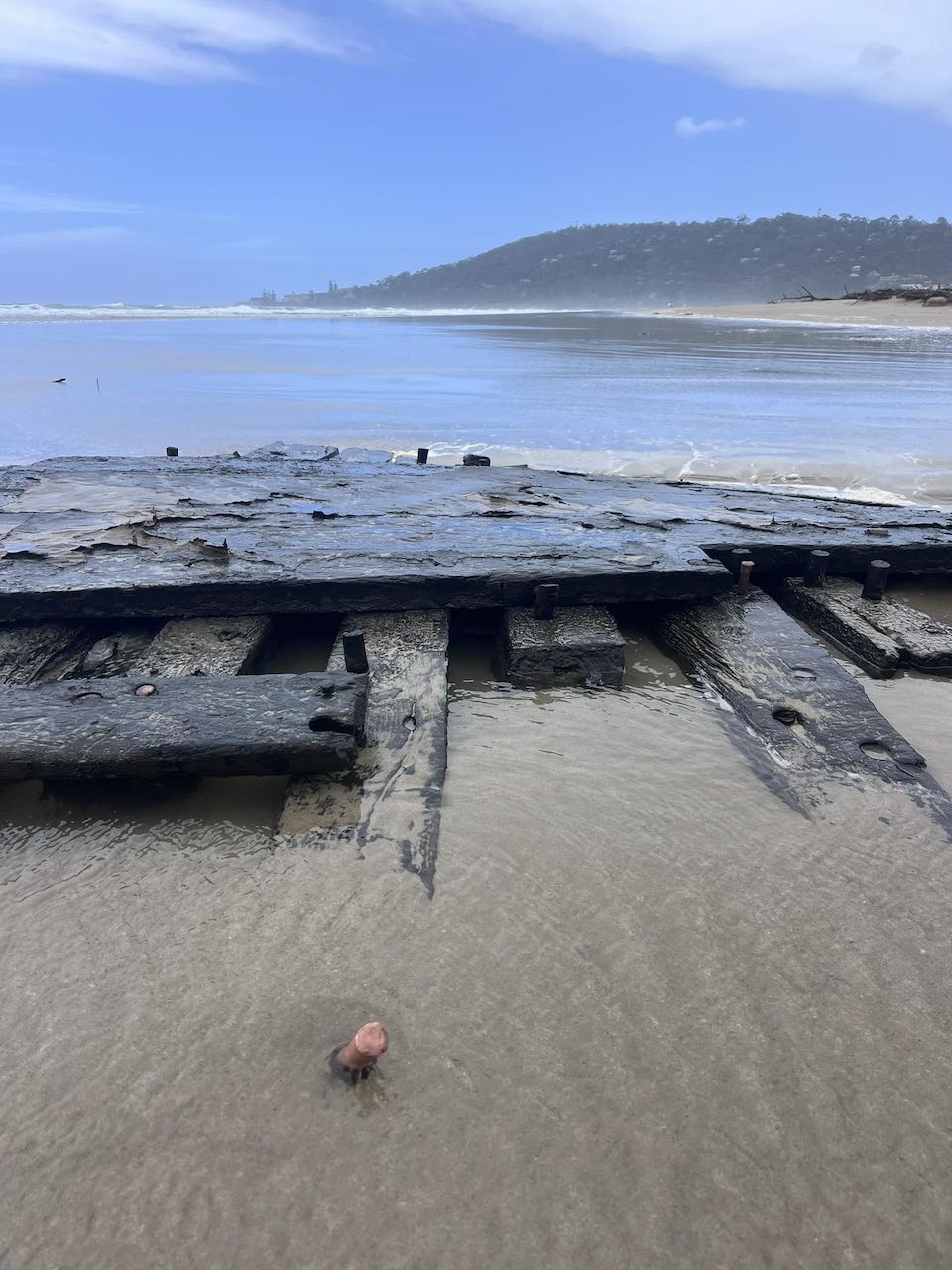
15 Jan 2026, photo posted on Facebook by James Pasco.
Walk towards the Swing Bridge and you should see the plaque shown below.
7. Swing Bridge

The first Swing Bridge was built in 1937 by the Public Works Department and the Winchelsea Shire for the sum of £850. Mr Hammerton, who lived just above the location of the Swing Bridge, was said to have gone around the town collecting donations to help fund the construction.
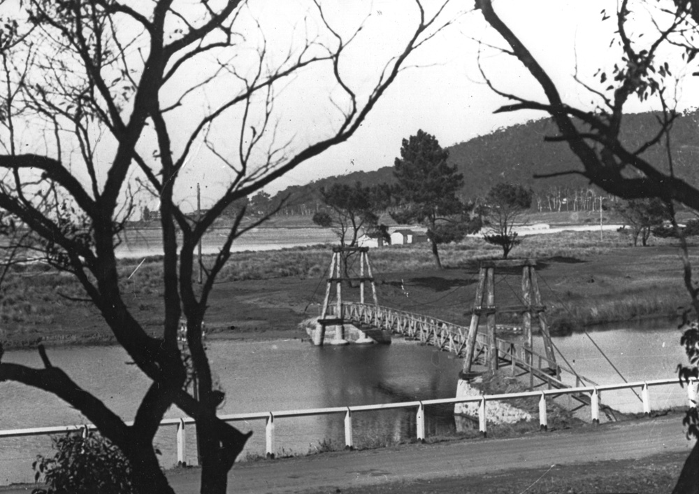
1937, first Swing Bridge
A new Swing Bridge was constructed and put in place by a crane on 21st March 2014. Read more…

The new Swing Bridge
Walk across the Swing Bridge and then turn right towards the ocean and go up the hill for about 30m to the Splitters Grave located between the footpath up the hill and the Great Ocean Road.
8. Splitters Grave
What is thought to have been the first non-indigenous family to live in Lorne in 1849, William Lindsay was put ashore from the schooner Margaret with his wife, Mary Ann Lindsay, and two children plus food and tools of his trade to harvest timber to later be shipped to Geelong. Lindsay split wood to make wooden shingles and boards, hence called a ‘Splitter’.
Unfortunately on 28 January 1850 tragedy struck. The Lindsays’ two small sons, William (8) and Joseph (4), had burrowed a tunnel into a sand cutting while playing near the mouth of the river. The tunnel collapsed and smothered them. Their grave can still be seen on the high ground near the Swing Bridge, suggesting quicksand was the cause of then children’s deaths, but it’s now thought it was the collapse of the sand bank. Read more…

Walk back down the hill towards the Erskine River bridge along the boardwalk.
9. Boardwalk
The boardwalk along the northern banks of the Erskine River was opened in 2001.

Walk along the boardwalk between the Erskine River estuary and today’s Great Ocean Road.
Stop just before the round-about, look up to see Waverley Avenue running between the Coachman Motel and the houses. The first house, hidden behind the trees, is Waverley, a very early stately home established in c1881, now on the corner of Waverley Avenue and Deans Marsh road. The house was destroyed in the 1939 Black Friday bushfire before being rebuilt in the 1940s.
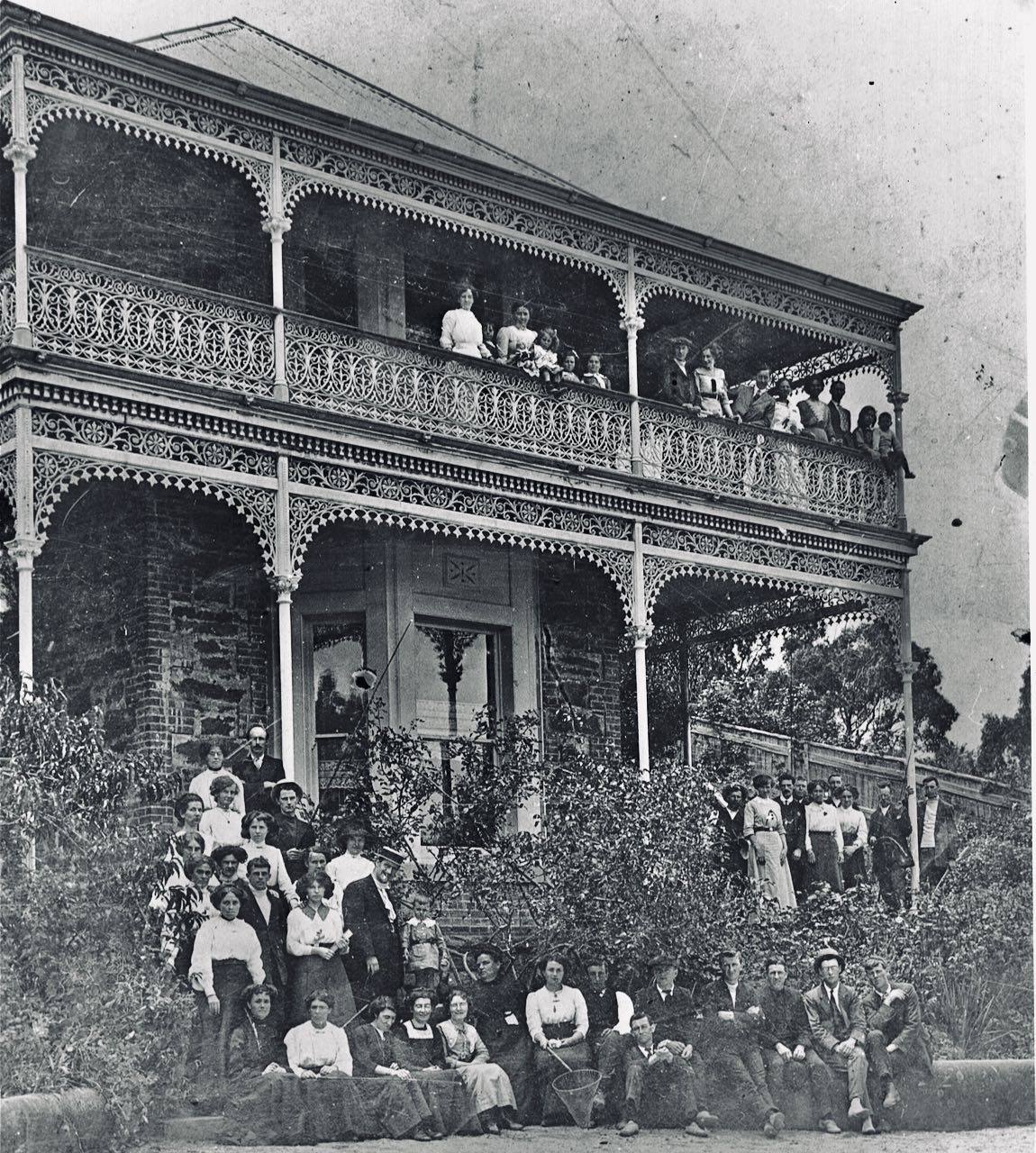
Early photo of Waverley
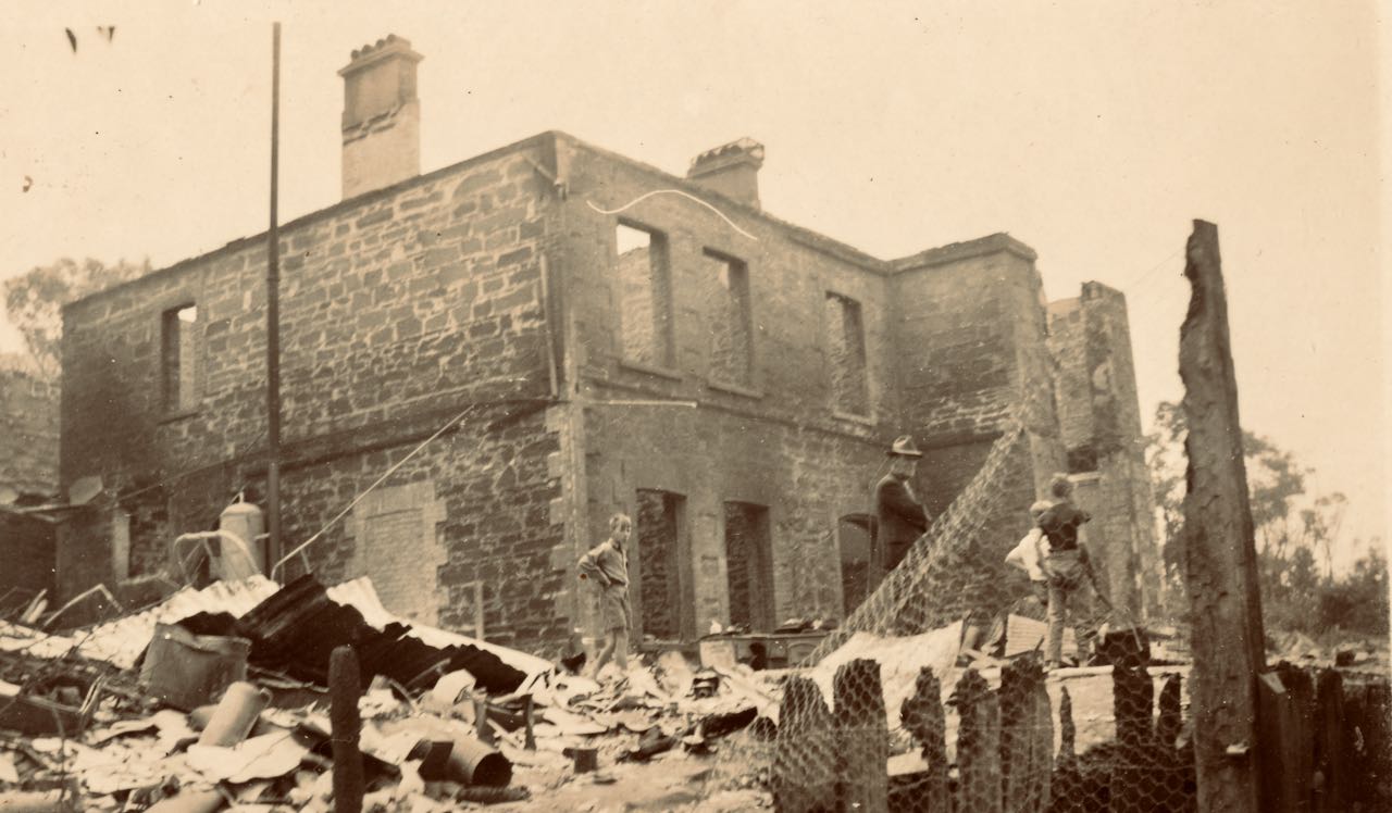
1939, Waverley after the Black Friday bushfire.
The first part of the Great Ocean Road connected Eastern View to Lorne in 1922. Before this, visitors to Lorne would come over the Otway Ranges via horse-drawn coach from Deans Marsh. The old coach road would pass in front of Waverley and the Coachman Inn before crossing the Erskine River at the ford.

1892, Mountjoy’s ran a coach service between the Dean’s Marsh Railway Station and Lorne. (Museums Victoria Collections)
Walk along the path between the caravan park and the Great Ocean Road then cross the Erskine River. Look to your right towards the Erskine River Shops.
You should see The Riverbank Cafe and the archway to the Kia-Ora Caravan Park. In 1875, Jesse Allen established a fruit and vegetable garden on the river flat, the current location of the caravan park, to supply produce to Erskine House.
10. Erskine River Shops
This precinct has a huge amount of historic interest for Lorne and the wider community. It dates from 1878 as an important commercial area and continues to this day to be a much-loved place for people to gather in Lorne and enjoy the ambiance of a 138-year-old business area. Read more…
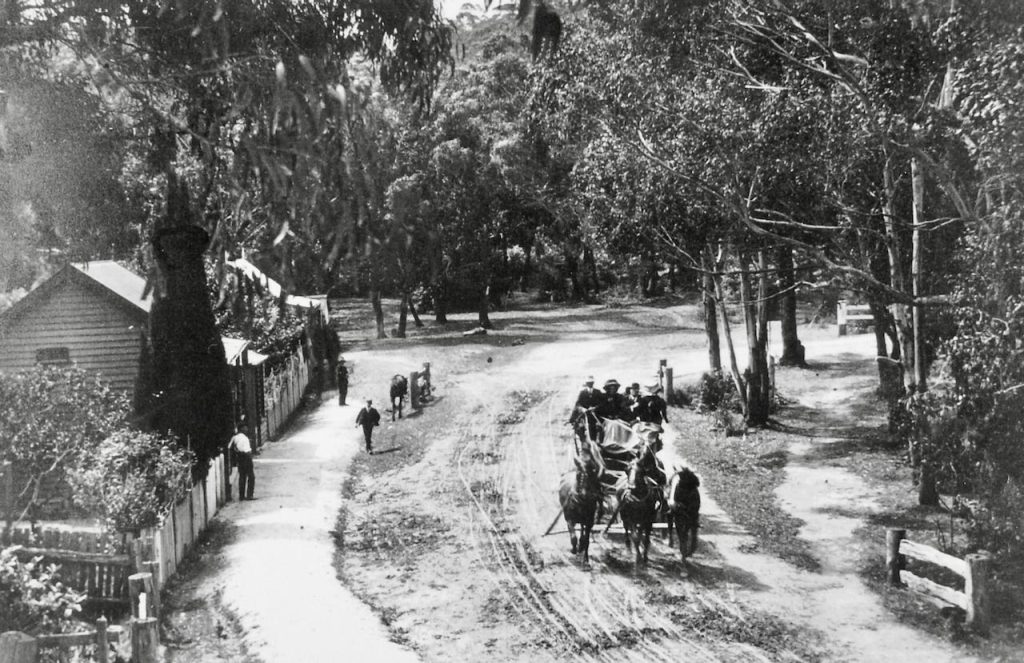
Pre 1910, Anderson’s shop not yet built. (LHS photo 171L)
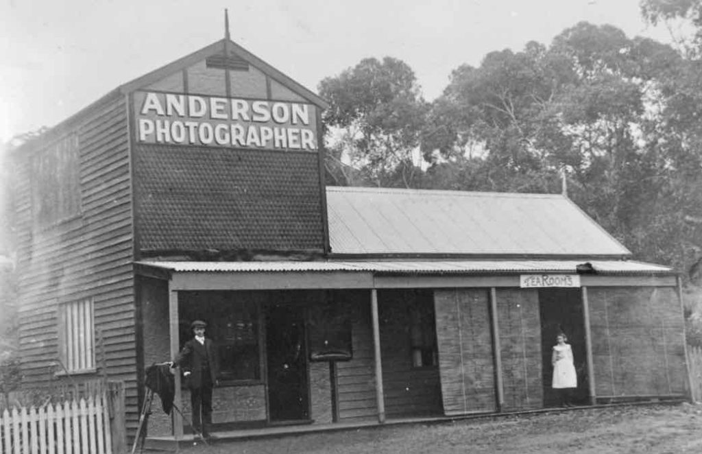
1910, Harold Anderson on the left.

2025, Becky McIntosh, Riverbank Cafe, 6 Mountjoy Parade.

1994, Rivergum
After looking at the shops, walk on back towards the oak tree to complete the Erskine River Loop Walk.
Sources:
- Lorne Historical Society Collections
- Google maps
- Walk map by Emma Jeantou